Ciao tutti!
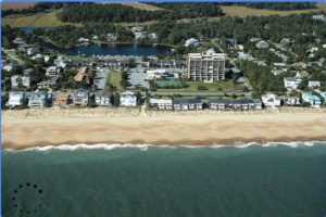
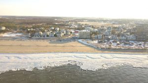
Let’s kick this post off with a confession…this is not a final outreach product but the next step towards a Drone CitiSci collaboration with the USGS’s iCoast. Revisiting the project concerns from the rough draft, all categories were addressed (in my opinion) and potential solutions are discussed here. Karen Morgan is my main point of contact at USGS St. Petersburg, FL along with the web developer for iCoast, Robert Snell. Pre and post storm drone photos from citizens would be a valuable addition to the current database of iCoast, which traditionally is comprised of photos taken from airplanes by USGS scientists. Including citizen drone photos enable greater spatial and temporal coverage of our beaches before and after storms to assess damages and morphology changes rapidly and accurately. Phase 1 of this project was a proof of concept determining if drones could create photos consistent with iCoast imagery and how should citizens then collect these photos. Examples photos are given below from iCoast and my personal drone. They look comparable! USGS currently uses iCoast photos to document coastal storm damages to the beach and surrounding infrastructure. Future work involves measuring features such as the shoreline, berm, dune toe, and dune crest for use in risk probability models by USGS.
Drone Imagery Collection Guideline:
- Determine if wind conditions are safe when flying before and after storms
- Make sure all people and animals are at a safe distance
- Before flying, enable the following parameters
Choose one camera exposure setting and keep it for all images
Angle camera such that the shoreline, beach, dunes, and infrastructure (if any) are visible
- Launch drone
- Fly drone 50 to 60 meters from the shoreline
- Use manual or automated flight controls to fly the drone along the shoreline
Set speed to 4.0 m/s and camera to timed photos every 5 seconds
- Fly as much of the coast as you like!
**Screenshots of instructions coming soon**
Examples:


Top figure is from USGS iCoast and the bottom figure was taken by me using a DJI Mavic Pro
Photos Submission Process:
- Create an account on iCoast using a Google email (https://coastal.er.usgs.gov/icoast/)
- Submit photos after logging into account via the Submission box (to be created)
**Keep all exif (properties info) in photos**
- Photos will be quality checked then uploaded to iCoast for classification by fellow citizens!
Launch Events and Recognition:
To get the word out about this project, events will be held during VIMS’ Science Day and UD’s Coast day once the webpage is updated to accommodate this project. Special interest groups such as school STEM classes/clubs, retired and current pilots, Boys and Girls Clubs, Boy/Girl Scouts, and Citizen Science webpages/groups and USGS contacts will be approached for involvement. I foresee this being a mix of personal visits, skype meetings, and electronic advertisements.
Further down the road, I’d like to give recognition to citizens who submit their first photos. Perhaps a button, pin, or badge such as the Horseshoe Crab counting system employed in Delaware. Then, as more photos are submitted, that user is given recognition on the iCoast home page for the number of cumulative photos they’ve sent.
